Geospatial Survey Team
Learn about the work of a geospatial surveyor and how geospatial survey is used in the heritage sector.
A day in the life of a geospatial surveyor
These days there are many different forms of surveyor, some of which you may have already heard of – building surveyor and quantity surveyor perhaps? – but others may leave you wondering just what do they do. Geospatial surveyor probably comes into the latter category and often raises a confused look amongst those new to the term…until you understand what they actually do underpins a lot of modern day activity and can aid discovery, unlock the value of our heritage, create jobs and growth within a modern economy.
Geospatial refers to the relative position of things on the earth's surface. A geospatial surveyor captures hundreds of images and scans millions of points to create highly accurate and detailed 3D models upon which other analysis and decisions are then made. Typically, the information you provide could influence the construction of roads, buildings, bridges, wind turbines and more. Your work could support multinational corporations, specialist land, air and offshore mapping companies, scientists, technologists and other land related professionals as well as many more.
We belong within a multi-disciplinary team that uses photography and cinematography, graphics and geospatial survey to record, illustrate and digitally document historic objects, sites, places and landscapes. We have a range of skills and expertise in knowing how to best use digital cameras, theodolites, laser scanners, graphics and photogrammetry software to derive engaging and innovative outputs that inspire others to explore and analyse heritage with new eyes.
No two days are the same for a geospatial surveyor mixing an enjoyable blend of time out on site, capturing the essential image and 3D point data ‘ingredients’, with work back in the office processing, analysing and combining it into a range of outputs.
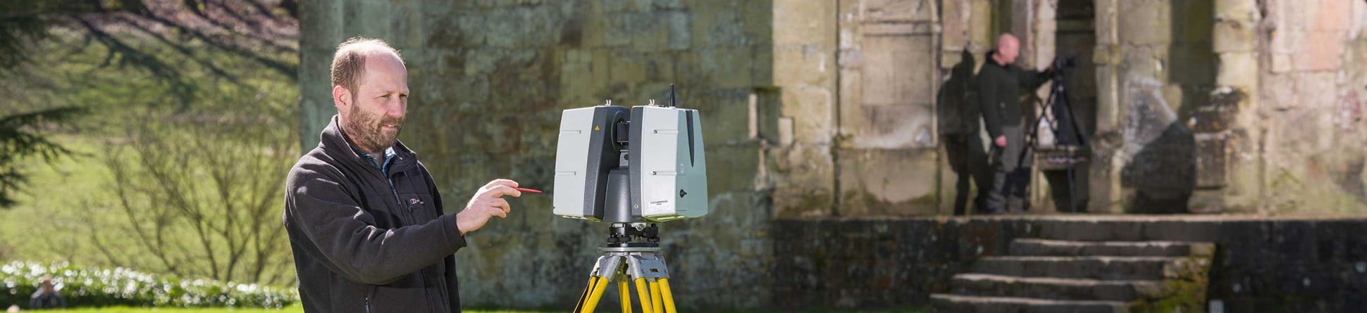
April 2018 - capturing survey data on site
Old Wardour Castle, set in the peaceful Wiltshire countryside, is an English Heritage (EH) site built in the 14th century as a lightly fortified but luxurious residence. It pioneered the inclusion of self-contained suites for noble guests and more recently was the inspiration for the castle featured in the Kevin Costner film 'Robin Hood, Prince of Thieves'. Less well known is it also contains a fantastic range of historical graffiti ranging from 16th century Tudor through to 20th century examples by American World War Two personnel. This was the focus of our collaborative geospatial survey work with EH to contribute visual materials for a proposed interpretive display.
After travelling to site the day before from our office in York, we started the day by carrying out an initial reconnaissance survey. Commonly known as ‘the reccy’ this is a vital first stage in any survey before equipment boxes are opened as it helps to better understand the practicalities and context of what is requested by the client. We then spent the next hour capturing three dimensional data from multiple locations within the area in question using one of our static laser scanners. We also worked on capturing hundreds of overlapping digital photographs of the graffiti itself, from which three dimensional representations of the historical graffiti could be photogrammetrically generated by him when back in the office.

May 2018 – data processing, analysis and output
Earlier in the year, we undertook several days of photogrammetric image capture of a number of First World War Memorials in Lancashire that had been listed as part of last year’s centenary listing project by Historic England (HE) and contributed to their First World War Memorials Programme. Working with colleagues from HE’s Planning, Conservation and Listings teams, we captured between 50 and 100 overlapping images of each memorial, using one of our DSLR cameras.
Once back in the office we processed these images using our ‘Structure-from-Motion’ photogrammetry software to provide a detailed, colour 3D model of each memorial which could be later viewed, manipulated and analysed by those interested in the appearance and condition of the memorial. One of these was 3D printed to provide a tactile model at 1:10 scale to aid in the future dissemination and education activities of the memorials programme.
Working with ‘state-of-art’ surveying equipment often attracts interest and attention from passing visitors and the occasional ‘What are you doing?’ So whilst the equipment is scanning or the photography is being captured we always enjoy explaining what we are doing, how the equipment works, what we hope to generate and why we are doing it which in turn helps to better understand the important role of the geospatial surveyor.
Geospatial survey webinar about its usefulness and challenges
View the 2020 webinar: Geospatial survey.
Geospatial survey encompasses a wide range of survey technologies for capturing three dimensional data and digital imagery of heritage objects, buildings and landscapes. Once processed the outputs provide accurate, scalable base documentation that aids a variety of applications including archaeological/architectural analysis, site presentation, condition survey, structural monitoring and conservation works planning.
This webinar discusses the heritage application of geospatial survey technologies. Through reference to two case studies, it considers their use for historic buildings and structures alongside some of the challenges faced when undertaking or commissioning survey work.
For the best webinar experience, please use Google Chrome browser or download Adobe Connect.


