National Archaeological Identification Survey: South-West Cambridgeshire
The project covers an area to the west of Cambridge stretching from the historic fen edge at Fenstanton to the Chalk Downs south of Royston. The first stage of the project used aerial photographs and airborne laser scanning (lidar) to identify and map archaeological remains over an area of 374 square kilometres.
The results were spectacular for the extent and variety of past land use visible from the air. Results from developer-funded excavations in and around the project area were used to propose possible dates and functions for many sites identified. The archaeological interpretations and mapping of this complex archaeological landscape will inform heritage protection and can be used to target ground-based work.

The south-west Cambridgeshire landscape
The project area is geologically and topographically diverse. It includes large parts of the river valleys of the Cam (or Rhee) and the Bourn Brook. The geological character of the northern half of the area largely comprises Jurassic clays, partly covered by glacial till. The southern half is mainly chalk. A band of Gault and Upper Greensand separates the two major geological zones. The varying character of the area and modern land-use influenced the known archaeological evidence.
Our knowledge of the archaeology of south-west Cambridgeshire and nearby parts of north Hertfordshire was patchy before we began this project.
West of Cambridge a number of development-led investigations provided detailed archaeological evidence for material culture and chronological development of past land use. The Bourn Valley had also been subjected to extensive academic landscape research by Dr Susan Oosthuizen.
Further south there is less excavation evidence but buried sites were previously identified from aerial photography of cropmarks.
In terms of aerial investigation there were a number of high quality but small area mapping projects in advance of development, and sporadic records from oblique photography. However, no systematic assessment of aerial photographs or lidar for the large areas in-between these studies had taken place.
The Historic England aerial investigation and mapping for the South-West Cambridgeshire project created over 1,200 new monument records within the National Record for the Historic Environment and amended a further 300. These will become available on PastScape and have been supplied to the Local Historic Environment Records. Although this is an impressive number of sites, the archaeological record seen from the air was also remarkable in terms of the extent and complexity of the remains recorded.
Aerial investigation and mapping
The results have revealed a diverse archaeological landscape, with monuments ranging in date from the Neolithic to the Cold War, and with a variety of functions such as funerary, settlement, agriculture and military.
Analysis of the results built on previous archaeological investigations and highlighted many subjects, of which just a handful are listed below:
- The distribution of Bronze Age funerary monuments
- The morphology of later prehistoric and Roman settlements
- Land division in the early medieval period
- The identification of medieval manorial moated sites
Issues raised included:
- The visibility and nature of archaeological features on different soils and bedrocks
- The potentially contentious subject of dating of features based on morphological characteristics
Clayland discoveries
Until recent years, areas with clayey soils were thought to have been largely avoided until the Roman period. However the South-West Cambridgeshire project illustrates a very different picture where multi-phased Iron Age and Roman settlement spread across the clayey tills north of Cambourne.
These discoveries are mostly the result of one year of targeted aerial reconnaissance and photography. This work was carried out when the conditions were optimal for the formation of cropmarks on the clay areas of the east midlands. The result is discovery of an extensive distribution of nucleated settlement groups. These are complex in nature and most likely originating in the Late Iron Age.
In contrast to the areas to the north and south, the settlements on the clay lands appear to be isolated. However, it is likely that, as in other areas, these sites were once linked by tracks and hollow ways (tracks which lie significantly below the level of the land either side). This suggests that only part of the Iron Age and Roman landscape on the clay has been recorded from the air. Much more remains to be discovered about how the settlements were linked.
Romans along the Rhee
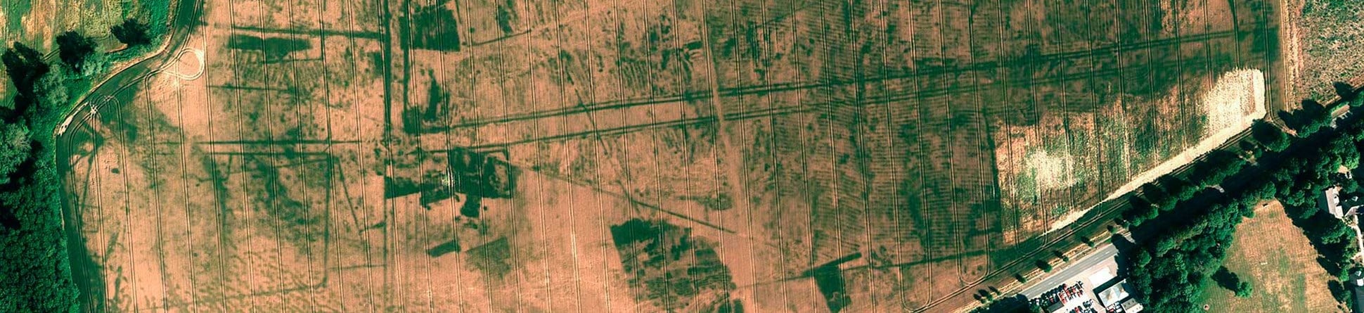
The aerial investigation and mapping also increased our understanding of the later Iron Age and Roman periods on the areas over chalk to the south of the River Cam or Rhee. The soils over chalk are usually conducive to the regular formation of cropmarks of buried archaeological features. The mapping from aerial photographs illustrates a dense pattern of settlement, now buried beneath the plough soil, interconnected by networks of trackways and hollow ways.
The densest concentration of archaeological evidence seen from the air was on an area of sands and gravels where the River Rhee and the Hoffer Brook join. A vast array of Roman activity occurred here. This is seen as cropmarks of large rectilinear settlements connected by a series of linear trackways or roads.
Stretching from Hoffer Bridge to Rushmoor Plantation, this Roman landscape appears to show a continuation of Late Iron Age activity, in places using the layouts of earlier settlements and trackways. The regularity and extensive nature of the cropmarks suggests a considerable level of organisation and limited excavations suggest a possible military origin.
Further west the Roman monuments are less imposing, but no less extensive. There are a number of settlements, villas and cemeteries, several of which were mapped from aerial sources.
Fossilised field systems
A few of the Roman sites excavated in south-west Cambridgeshire appear to have continued in use after the end of official Roman control in Britain around 410 AD. Continuity of settlement in the area is also suggested from the presence of early medieval cemeteries across the project area. However, early medieval remains can be difficult to positively identify from non-intrusive survey methods unless they have very distinctive forms. Only a small number were mapped during the project.
On the other hand, this period may have seen the origins of one of the most numerous types of feature mapped during the project. These are the extensive field systems comprising networks of low-spread earthwork banks. They survive as low earthworks, some difficult to see on the ground but readily visible on lidar. Though these banks often remained in use until the enclosure acts of the early 19th century, many may have originated in the early medieval period, before the Norman Conquest in 1066.
These long sinuous furlong boundary banks stretch across much of the Cambridgeshire landscape forming long parallel rows of land division. These were later used and enhanced by extensive medieval cultivation.
Protecting Cambridgeshire's heritage
Potential threats to the archaeological resource, especially in the northern part of the project area, include the likelihood of further development around the new towns of Cambourne and Northstowe, and on a smaller scale in several of the historic villages.
Major transport routes in the area, especially the A14 and A428, are likely to be upgraded, while there are proposals for a new railway line between Sandy and Cambridge. The project outcomes, combined with the results of past and on-going developer-funded work will help inform future planning for housing and infrastructure.
The results of the project will aid management of this landscape by enhancing the local Historic Environment Record (HER) and other databases, and by raising awareness of its archaeological potential among curators, academics and local communities.
The images used on this page are copyright Historic England unless specified otherwise. For further details of any photographs or other images and for copies of these, or the plans and reports related to the project please contact the Historic England Archive.
For further information on a project or any other aspect of the work of the Remote Sensing Team please contact us via email using the link below.
Archaeological Investigation
-
Email
[email protected]
-
Address
EC4R 2YA


