Drones for Heritage Uses
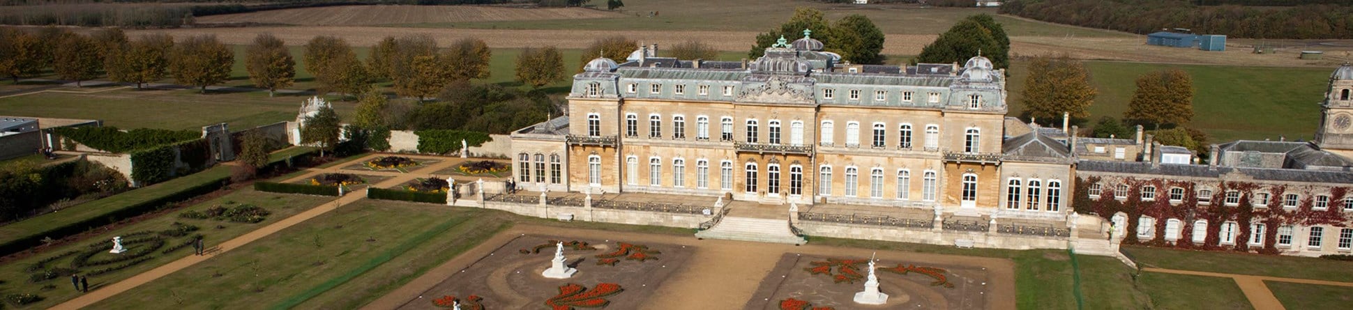
Drones provide a useful low-level aerial platform for recording historic buildings, monuments, archaeological sites and landscapes. They can carry a wide variety of sensors including cameras, multi/hyperspectral imaging units, and even laser scanners. Drones can provide dramatic illustrative photographs of sites, but can also be used to create metrically accurate records for survey and conservation work . However, care needs to be taken to ensure drones are used in a way that is safe to both people and the historic fabric being recorded.
Although drone is the term most commonly used by the media and recognised by the public, other acronyms are these days used when referring to such low-level aerial platforms including:
- UAV - Unmanned Aerial Vehicle (often referred to by academic researchers)
- UAS - Unmanned Aircraft System (referred to within Civil Aviation Authority - CAA regulations)
- SUA - Small Unmanned Aircraft, (the acronym currently preferred by CAA-UK, TSA & Historic England)
- RPAS - Remotely Piloted Aircraft System (now promoted across Europe within context of their civil use in the EU). This is how they are referred to in the House of Lords Select Committee report on the Civil use of remotely piloted aircraft systems (RPAS) in the EU

Types of aircraft
Two types of craft are typically used for heritage related applications:
Rotary Wing
Advantages
- able to hover & operate in confined spaces
- can carry heavier payloads
- can carry a range of sensors including DSLR still & HD/4K video cameras, lidar and terrestrial laser scanners
- gyro-stabilised mounts typically used
- camera RAW output = better quality of imagery
Disadvantages
- shorter battery life & slower flight speed = shorter range of operation
- pre-planning of flight route not universally supplied or used by operators
Fixed wing
Advantages
- longer battery life & faster flight speed = longer range of operation
- can glide over long distances and survey larger areas in ‘strip’ form
- pre-planning of flight route, image acquisition and overlap commonly supplied by manufacturers
Disadvantages
- design means smaller & lighter payloads
- typically limited to compact digital cameras
- lack of camera RAW output, commonly restricted to JPEG = lower quality of imagery
Regulations
UK use is typically restricted to a combined weight of less than 20kg for both drone and camera or other sensor. All aircraft, irrespective of their size, that are used within UK airspace for aerial work and for commercial gain (a valuable consideration) must comply with CAA regulations and permissions as outlined in CAP 722.
Further guidance on the survey application of drones is provided by The Survey Association (TSA) within their Client Guide on Small Unmanned Aircraft (SUA) surveys
Heritage use of drones
Historic England has used drone acquired imagery since 2008 and has built up long experience of using such platforms alongside other means of capturing low-level aerial imagery such as masts, kites, balloons, helicopters and planes. There is a growing use of these aircraft across the heritage sector .The imagery and data they capture can be used across multiple applications including monitoring, presentation, interpretative display, multimedia journalism, surveying, mapping and recording.
- Monitoring of sites
- detailed analysis of high level wall top and roof condition
- archaeological recording of excavated features
- capture of still and video imagery allows both real-time and off-site analysis of condition
- typically captured by rotary platforms due to the need for high-resolution oblique imagery from specific viewpoints
- Presentation and interpretive display
- On-site display using still, video and virtual images
- Illustrations within guidebooks, journals, newsletters, research reports and websites
- Typically captured by rotary platforms due to need for oblique imagery although some fixed wing platforms now offer an in-flight ‘tilting’ function
- Surveying, mapping and recording - coupled with the growing use of Structure from Motion (SfM) drones offer the possibility to use the imagery in new ways.
- Generation of 3D surface models for landscape and buildings
- Overlapping still imagery (typically 80% forward & 60% side) processed using Structure-from-Motion (SfM) software e.g. Pix4D & Agisoft Photoscan
- Can be captured by rotary & fixed wing platforms
- landscapes typically fixed-wing
- buildings typically rotary-wing
- Guidance is being prepared by Historic England
For further information on a project or any other aspect of the work of the Remote Sensing Team please contact us via email using the link below.
Archaeological Investigation
-
Email
[email protected]
-
Address
EC4R 2YA


