Uncovering the Hidden Gardens at Marble Hill House
In 2017, to support English Heritage plans to enhance the presentation of Marble Hill House and Park Historic England archaeologists worked to uncover hidden landscape gardens dating from from the 18th century, as shown by a plan of 1752, that were loved by the fascinating Henrietta Howard, mistress of George II and Countess of Suffolk, for whom Marble Hill House was built from 1724-1729.
Henrietta was not considered a traditional 'beauty' but well known and much loved for her radiating charm, wit and intelligence. Henrietta became the royal mistress of King George II for 16 years, retiring from court life in 1734. In 1735 following the death two years earlier of her abusive, drunken first husband, Charles Howard, she remarried for love to the Honourable George Berkeley, an MP. Following 11 years of very happy marriage, Henrietta was widowed again and retired permanently to Marble Hill House surrounded by her many friends, including Alexander Pope, Lord Chesterfield and Horace Walpole.
The excavations were part of a wider research effort including geophysical survey, earthwork survey and aerial photograph analysis.

The grotto
The excavations led us us to discover that the grotto itself has a complex history.
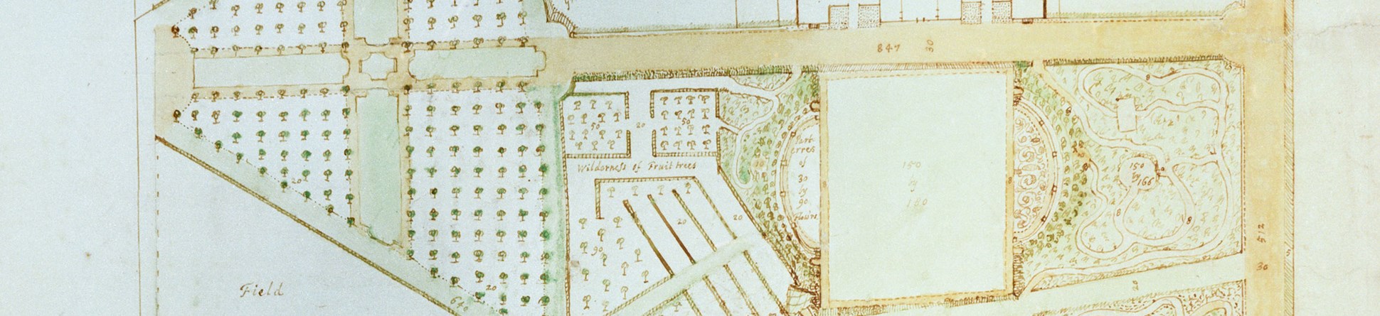
We discovered the edge of the grotto which matches with the 1752 garden plan. We also found evidence of a series of digging events related to the creation of the hole for the grotto, gravel extraction, infilling to reduce the size of the grotto, an interval of a series of linear planting beds, and a large infilling which probably represents the decommissioning of the grotto. We also found cuts relating to a network of sunken paths leading to the grotto, one of which corresponded very closly to the position of such a path on the 1752 map. What the excavations have revealed is a new chapter in understanding the history of the grotto.
Ninepin bowling alley
We have interpreted a shallow feature with a possible lozenge shape as the bowling alley. The linear feature is aligned east to west, exactly as it appears on the 1752 garden plan. The linear feature is also exactly 18 feet wide indicating that someone has taken the time to measure this exact width. It also appears to have been patched up over time due to wear and tear.
Ice house seat
At the last minute, we got permission to place a trench behind the ice house to investigate the existence of a seat. This was no small seat, but quite a hefty structure which appears on the 1752 plan in a roofed alcove, designed in the same style as the house itself and facing an avenue to the river.
It was a race against the clock to excavate what we could in a short timeframe – just four days to dig and find some information. We didn’t find the seat itself although we did gain more of an understanding of the bank leading down from the ice house. We discovered three different phases of bank building and modification, one of which very possibily relates to the seat itself. We think the seat is situated a lot closer to the ice house than we were able to excavate.
What other finds did we make?
We found a lot more than we anticipated. From medieval pottery made in nearby Kingston, to yellow bricks made in Kent or Sussex, to 18th century clay tobacco pipes including one with an inscription. We also discovered quite a bit of glass including a complete 20th century milk bottle from Cross Deep, Twickenham. We found a fragment of dressed Marble which is a possible tile. We also found evidence of an 18th century drain running from the house to the river, and an 18th century culvert.
Landscaping on the lawns?
We could see clearly that there was minimal evidence of landscaping and the raising up of the lawn. We could see this through the absence of evidence for an earlier turf line, the absence of a buried soil horizon and the fact the depth of the topsoil (20 centimetres) was the same at the top and bottom of the trench.
Therefore, all of our trenches on the lawn indicate to us that in fact the break of slope is not artificial but that the topography of the landscape is natural with only very small changes made through landscaping in the early 18th century. The trenches here did not locate Italian Gardens thought possibly to have been in this area.
Inspiring budding archaeologists
The excavations were opened to students visiting from local primary and secondary schools. It was fantastic to open up our excavations, share our archaeology and, we hope, inspire possible budding archaeologists. The students also spent some time looking at and asking questions about what we had found as well as doing hands-on activities about Grottos, shells, animal bones and knuckle bone floors.
Earthwork survey
The pleasure grounds begun in 1724, saw the involvement of both the famous landscape architect Charles Bridgeman and the poet Alexander Pope, a long standing friend of Henrietta, who may have had a hand in the design. The extent of Pope's influence has been a matter of debate. Some small-scale features, several revealed by the earthwork survey, suggest that Pope’s design may have been implemented. The width given for the cross walk on the 1724 plan (30 feet) is almost exactly that suggested by the earthwork evidence. At the eastern end of the cross walk, quarter-circular features to north and south may be visible in the earthworks, and some of the unexplained features to the west of the slope down from the terrace may relate to the walks that appear on the 1724 plan.
Perhaps the most significant discrepancy between the two plans is the westward extension of the garden; the 1724 plan shows the cross walk extending further west than in 1752 and ending in a semi-circular area, the focus of several walks and perhaps intended to house some sort of ‘eye-catcher’. The 1752 plan shows an octagonal feature in this area and though it appears on that plan to be south of the line of the cross walk, Historic England’s surveys all show the feature to have been directly in line. This could therefore be a remnant of the earlier layout, for it is difficult to see why otherwise it would have been sited here, at the bottom of a slope and not particularly prominent.
Later use of the parkland
The aerial survey has revealed the extent of the park’s wartime use. Typically, most of West Meadow and the southern third of East Meadow were given over to allotments with the northern two thirds apparently ploughed for pasture. This use persisted for a surprisingly long time, with large areas of allotments surviving into the 1950s and the last area only being removed in the early 1960s. Despite the urgent need for home-grown food during the war, the whole park was not converted to allotments. Parts were kept for sport; the areas north and south of the house featured football pitches, tennis courts and perhaps cricket squares. No doubt this helped maintain morale and fitness, and kept local children occupied.
Further reading
Alexander, M, Carpenter, E et al 2017 Marble Hill House, Twickenham, London: Landscape Investigations. Portsmouth: Historic England Research Report Series 5-2017
Alexander, M 2017 'Reconstructing the Parkland at Marble Hill House', Historic England Research Issue 7
Linford, P, Linford, N et al 2016 Marble Hill Park, Twickenham, London: Report on geophysical surveys, December 2015 and February 2016. Portsmouth: Historic England Research Report Series 19-2016.
A summary of the Phase 1 excavations carried out in November 2016 can be found here
The Conservation and Environmental sections will be added when complete.


