Researching Sunderland's Heritage Action Zone
Exploring the history and architecture of a city.
Sunderland was, in 2017, one of the first places to be granted Heritage Action Zone (HAZ) status by Historic England. Since then, the organisation has been working with Sunderland City Council and local partners to bring historic buildings to the forefront of regeneration and development in an area around the city’s historic high streets. Historic England is contributing significantly to the HAZ, offering planning advice and grants, updating listings and funding a project officer post, while also carrying out targeted research.
The city of Sunderland is formed from three separate historic settlements: Monkwearmouth on the north side of the Wear, and Old Sunderland and Bishopwearmouth on the river’s south bank. They had come together by the late 18th century, with the high streets of Old Sunderland and Bishopwearmouth meeting at the junction with the newly laid-out Fawcett Street. Fawcett Street ran north–south and linked with the bridge over the Wear to Monkwearmouth; the bridge was completed in 1796.
The commercial focus of Old Sunderland had been its own high street but this focus shifted westwards along the newly combined high street and onto Fawcett Street. The city’s commercial heart moved again in the later 20th century with the building of the Bridges shopping centre to the west of Fawcett Street. Slum clearance, two World Wars and post-war rebuilding have all transformed the city, leaving pockets of important historic buildings in the midst of later developments, and a legacy of vacant sites and underoccupied commercial buildings on the former high streets. High Street East and High Street West (the combined high streets of Old Sunderland and Bishopwearmouth, as bisected by the post-war inner ring road and renamed), and Fawcett Street thus form the heart of Sunderland’s HAZ.

Research into the history and development of the area, and into its surviving historic buildings, is a key part of the wider HAZ project. Each of these areas of work combines existing knowledge with information gained from the buildings themselves, in order to inform future development and contribute to sensitive, viable restoration.
Two projects consider the HAZ and its immediate surroundings.
The first is a Historic Area Assessment. This has been commissioned from consultants Wardell Armstrong, and brings written and pictorial resources together with a detailed examination of the area’s buildings, in order to provide an overview of the area’s history, development and significance. To inform the Historic Area Assessment, Historic England staff examined the collection of historic aerial photographs of the HAZ and its surroundings in the Historic England Archive (Oakey 2018). Key individual buildings within the HAZ have also been investigated and researched by Historic England’s Historic Places Investigation Team. These include the commercial complex of Hutchinson’s Buildings, with its landmark structure at Mackie’s Corner; the late 18th-century Phoenix Hall; a trio of surviving houses-turned-commercial premises at 170–5 High Street West; and Athenaeum Buildings on Fawcett Street.
Sunderland in aerial photographs
The Historic England Archive holds a collection of over four million aerial photographs dating from the early 20th century to the present day. These provide a unique and engaging record of the historic environment, recording lost or radically altered aspects of our rural and urban landscapes, and capturing ephemeral elements which would otherwise go unrecorded. Although more commonly associated with discovering and recording archaeological sites, aerial photographs can be a valuable resource for those investigating villages, towns and cities.
The inter-war city
The earliest photographs of Sunderland in the collection are three low-level oblique photographs taken by Aerofilms late on a summer afternoon in April 1924. They illustrate the commercial district: the scene is busy with pedestrians and unfurled shop awnings displaying proprietors’ names. These, and other images taken in 1928 and 1936, are of particular value as they capture the city before the outbreak of war and subsequent redevelopment.
By the early 20th century, large areas of Sunderland’s East End were classified as slum housing. A programme of clearance had begun in the 1930s, when many of the terraced streets in the East End were replaced by large blocks of low-rise social housing in the Moderne style (combining Art Deco and traditional elements), known as the Garths. These were largely demolished in the 1990s but aerial photographs provide a record of them shortly after their completion. Six developments were constructed by the North Eastern Housing Association between 1937 and 1940. The largest were Wear Garth and Burleigh Garth, quadrangular four-storey blocks of three- to five-roomed flats. With their balconies and communal outside spaces, the Garths stood in stark contrast to the overcrowded and insanitary conditions in which residents had previously been living.
Sunderland at war
Sunderland’s docks and shipyards made the city a prime target for the Luftwaffe during the Second World War. The first air raids came on the night of 21 July 1940, and by the cessation of hostilities in 1945 several areas of the city had been destroyed or rendered uninhabitable. RAF photographs from 1941 show the scars of the early air raids, but perhaps more striking are a series of large-scale photographs from 1945 and 1946 which record Sunderland in the months immediately after the war.
Within the area of the city assessed by the project, over six hectares of housing and commercial premises had been cleared by 1945. Some of the most extensive damage can be seen around the docks and the densely-packed terraced housing of the East End. In the commercial district and town centre significant buildings, such as St Thomas’ church and Victoria Hall, had been destroyed. By 1946 some of these cleared areas were being used as temporary car parks; they were redeveloped in the 1950s.
Local authorities had been responsible for the provision of public air raid shelters since the 1937 Air Raid Precautions Act, and numerous shelters are visible on 1940s RAF photographs. Some of the larger terraced houses had domestic shelters in their back yards. In contemporary newspaper adverts, Binns department stores even offered ‘all the equipment you need’ to furnish them. Many other residents had to take refuge in communal and public shelters. Large complexes of covered trench shelters were constructed within the Garths, but the most substantial were located on Town Moor and in Mowbray Extension Park. These could accommodate close to 3,500 people in total.
Prefabs to point blocks – redevelopment of the East End
Apart from the development of the Garths, aerial photographs from 1945 show a street pattern that was largely unchanged since the early 20th century. However, a series of redevelopments from the 1950s onwards radically altered large parts of Sunderland’s streetscapes. Some of the most significant changes were in the East End, where the remaining terraced houses were largely swept away and replaced by modern housing schemes, each of which reflected evolving ideas on town planning.
The Sunderland blitz had destroyed 1,200 homes. Around 35,000 further buildings suffered bomb damage. The city, like many across the country, turned to prefabs as a cost-effective temporary solution to the housing problem. Numerous designs were constructed nationally, but those in the project area were manufactured by Tarran of Hull. RAF photography from 1945 shows two such estates under construction, each with an electricity substation to service the electrical goods, such as cookers and refrigerators, which were part of each prefab’s fit-out. By 1948 the residents had clearly settled in: RAF oblique photographs show several prefabs with rear vegetable gardens.
Aerial photographs continue to document the changing housing of the East End throughout the 1950s and 1960s. The earliest development – seen under construction in a 1958 RAF oblique photograph – retained the original street plan but replaced the terraced housing of Wear Street, Zion Street, Hendon Road and Moor Terrace/Adelaide Place with a mixed development of maisonettes and flats set within communal grounds. The current housing retains this plan but the original blocks have since been replaced by two-storey terraces.
Sunderland was a relatively late adopter of high-rise housing. In 1964 Harvey Bishop was appointed as the borough architect. He was an advocate of prefabricated ‘system’ building, and oversaw a shift in urban planning in which new tower blocks radically altered Sunderland’s skyline. The first were in the Coronation Street redevelopment area, where two 11-storey blocks were constructed. Both have since been demolished. This was followed by the Hendon Road, Walton Lane and Town Central Area developments, which were constructed through the 1960s. Much of this post-war landscape was lost or considerably altered in the later 20th century, leaving the aerial photographs as one of the only visual records of this significant period in Sunderland’s architectural history.
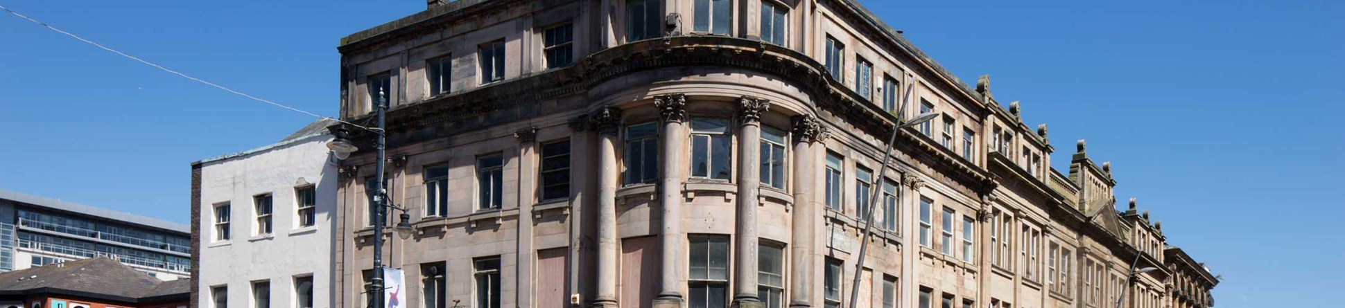
Hutchinson’s Buildings and Mackie’s Corner
Hutchinson’s Buildings and the domed Mackie’s Corner have been Sunderland landmarks since they were completed in 1850. The buildings are prominently sited at the intersection of High Street West, Bridge Street and Fawcett Street. They were constructed as a terrace of self-contained properties, with shops on the ground floor and residential accommodation for shop tenants and staff above. The whole complex was fronted with a grand classical façade in the manner of London’s Regent Street and Newcastle’s Grainger Town. The design united the separate properties by being wrapped around the two principal elevations; a landmark was created by placing a dome on the corner.
The names of the complex were coined early. The site’s developer was Ralph Hutchinson (born c 1813), a ship builder, ship owner and timber importer. He employed George Andrew Middlemiss (c 1815–87) to design the buildings; his name is carved into the drum of the dome.
People met at the corner, where they could watch the hats being made.
Mackie’s Corner is the name most often used locally for the complex, though more accurately it refers just to the corner premises, whose first tenant was Robert Mackie, a maker and seller of silk hats. People met at the corner, where they could watch the hats being made as they waited, whilst keeping an eye on the clock faces installed by the town council in 1855. Mackie’s operated from Hutchinson’s Buildings until 1878, but key retailers, particularly drapers, grocers, boot-makers, restauranteurs, confectioners, milliners and furriers, had premises there into the mid-20th century.
Hutchinson’s Buildings were badly damaged in Sunderland’s ‘Great Fire’ of 1898, which started opposite to the complex, at Havelock House, a vast drapery on the corner of Fawcett Street and High Street West. Mackie’s Corner and the Bridge Street wing were unaffected, but much of the High Street West part was burned out internally, its stone façade cracked and spoiled. It was pulled down and rebuilt by the architect Henry Potts in a style sympathetic with, but not identical to, the original design. Although shops continued to operate from the ground and first floors of the new building, the second floor became ‘chambers’ or rentable office space accessed via a doorway from High Street West, behind which was a magnificently tiled hallway and an exuberant stairway. A commercial photography studio was built on the third floor.
In 1987, the ground and first floor of the 1899 part of Hutchinson’s Buildings were transformed into a nightclub, radically changing the internal layout and obscuring most of its historic features. Since its closure, and that of the shops in Mackie’s Corner, Hutchinson’s Buildings had been vacant for many years before the current owners started to bring the complex back into use at the end of 2017. Our research and investigation highlights the significance of the buildings for the history of Sunderland as it enters a new phase in its life, and our report on the structure will be published later this year (Jessop & Wilson 2018).
Phoenix Hall
England’s oldest purpose-built masonic hall still in use by Freemasons
Phoenix Hall, Queen Street East, is a building of exceptional history and significance in the HAZ. It is England’s oldest purpose-built masonic hall still in use by Freemasons; constructed in 1785, it is listed at Grade I. It was built at the southern end of the burgage plot occupied by the Golden Lion Inn, which stretched from High Street East southwards along the western side of Queen Street, then a long, narrow lane. The original structure consisted of a tall lodge room or temple (used for masonic ceremonies and dining) built over a basement, with a small lobby either side under a sloping roof.
The building has undergone many changes, although the original temple and much of the southern elevation survives. In the late 19th century, the brethren of Phoenix Lodge bought and remodelled the adjoining tenements along Queen Street, constructing within them a basement kitchen and a ground-floor banqueting room. The western lobby was demolished, and in 1925 a two-storey addition was built at the rear, creating a new entrance, storage and meeting rooms, and a flat for the caretaker. Where once Phoenix Hall was surrounded by a network of narrow streets, tightly-packed buildings and coaching inns, now its neighbours are tower blocks, car parks and industrial units, but moves are now afoot to improve both its setting and its accessibility. Research has included surveying and investigating the building and its location, so as to understand and articulate the local and national significance of this most intriguing structure. A report, by Tristan Wilson, will be published later in 2018.
Other building investigations
We have carried out a number of other more rapid investigations, so as to provide timely advice for the development of individual buildings within the HAZ. 170–5 High Street West is currently being rescued from near dereliction by the Tyne and Wear Building Preservation Trust. This terrace of three houses of about 1800 is a rare survival of the sort of buildings constructed along High Street West in the late 18th and early 19th centuries, as the settlements of Sunderland and Bishopwearmouth became conjoined. They were probably built as residential properties, but the ground and first floors were occupied by businesses as the area became increasingly commercial and the well-to-do decided to live elsewhere. Each originally had a small yard or garden with a stable and coach house accessed from Villiers Street at the rear.
Athenaeum Buildings declared the town to be a place of arts and culture rather than just a commercial and manufacturing powerhouse.
Athenaeum Buildings, on Fawcett Street, represents a later generation of Sunderland’s commercial buildings. The original Athenaeum of 1839–40 was built as a museum, library, and meeting place; it was another landmark Sunderland building from the start, with a massive portico dominating Fawcett Street. Its construction declared the town to be a place of art and culture rather than just a commercial and manufacturing powerhouse. Its later occupier, the Sunderland Liberal Club, rebuilt most of the structure in 1900, creating ground-floor shop units with new club rooms above. Investigation has shown that much more of the original building survives than previously thought; this dictates the outline of the building, and visibly survives on its rear elevation (Jessop 2018).
Sunderland has long been an important city. It has faced many challenges, particularly in the second half of the 20th century, but it now has the opportunity to reconcile the often opposing concepts of building for the future and valuing the legacy of the past. The HAZ’s emphasis on partnership, research, grant-giving, and advice helps to celebrate the city’s built heritage and to put it at the heart of plans for further regeneration.
About the authors

Lucy Jessop PhD
Senior Architectural Investigator with Historic England.
Lucy trained as an architectural historian and has worked for Historic England and its predecessor for over 12 years, investigating historic places and buildings primarily in the north of England. She is the project manager for the research component of the Sunderland HAZ.
Matthew Oakey MPhil
Aerial Investigation & Mapping Manager with Historic England
Matthew has worked as an archaeologist since 2002, specialising in air photo interpretation and mapping. He currently manages the northern Aerial Investigation & Mapping team, part of the Historic Places Investigation Team.Further information
Jessop, L and Wilson, T 2018 Hutchinson’s Buildings, 1 and 1a Bridge Street and 101–9 High Street West, Sunderland: Investigation, Research and Assessment of Significance. Historic England Research Report 28/2018, available soon at: https://research.historicengland.org.uk/
Jessop, L 2018 Athenaeum Buildings, 27 Fawcett Street, Sunderland: Investigation and Research. Historic England Research Report 27/2018
Oakey, M 2018 Sunderland Heritage Action Zone: An Assessment of the Historic England Archive Aerial Photographs.Historic England Research Report 22/2018
The Historic England Archive's collection of aerial photographs
See also Britain from Above
More images of research into Sunderland's Heritage Action Zone
An image gallery with further images from our research into Sunderland's Heritage Action Zone. Click on the images to enlarge them
 Historic England Archive RAF Photography")
, Historic England Archive RAF Photography.")
, Historic England Archive RAF Photography.")
 ©Crown Copyright, MoD")


