Mapping Climate Hazards to Historic Sites
A novel cross-sector approach to mapping the key climate hazards faced by the historic environment in the UK, at present and in the future.
About the climate hazard mapping initiative
Having survived many hundreds of years, many might assume that heritage sites and the historic environment would be able to withstand all possible threats posed by the natural environment.
Recent research however, suggests that a rapidly changing climate will intensify existing threats and create new hazards, both to historic sites and to their inhabitants.
The threats include overheating buildings leading to cracking of materials, sea level rises accelerating coastal erosion, and seasonal variations worsening the shrinking and swelling (‘soil heave’) of clay subsoils beneath historic buildings.
In order to address this, a consortium of UK heritage organisations (including Cadw in Wales, Department for Communities Northern Ireland, Historic Environment Scotland, Historic England, the National Trust and the National Trust for Scotland), have come together to develop a cross-sector approach to identifying and mapping the key climate hazards threatening UK heritage sites.
The approach, piloted by the National Trust in partnership with 3Keel (an Oxford-based sustainability advisory specialising in mitigation of and adaptation to climate change impacts), combines data on existing and projected weather patterns, underlying soil morphologies and hydrology with heritage site locations to map the present and future climate risks faced by these sites.

Understanding risks to sites
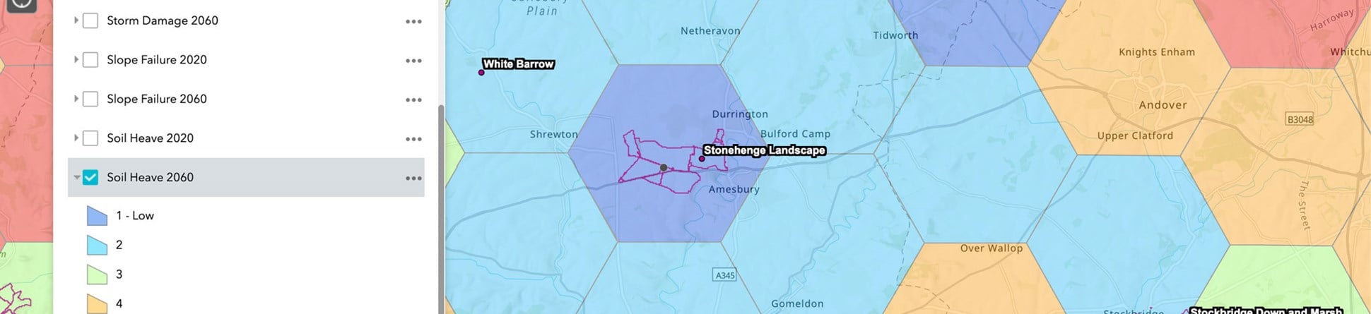
Through a process of stakeholder consultations, literature research, and site case studies, a number of hazards were initially identified as the key climate-related threats to heritage sites. These were overheating & humidity, flooding, slope failure leading to landslide, soil heave, storm damage, and coastal erosion.
By classifying each of these hazards and their relevance to sites, it was possible to identify ‘thresholds’ above which an increased level of climate risk was faced by sites. For example, wind gusts above 27 metres per second (60 miles per hour) would constitute ‘storm winds’, while precipitation above 50 millimetres per day would constitute ‘extreme rain’.
Using GIS mapping it was then possible to combine thresholds and climate projections, provided by the Met Office for a business-as-usual scenario, with other data, for example, underlying soil types and stabilities, flood plain locations, coastal erosion rates) to develop a pilot tool mapping the likelihood of hazard occurrence in 5 kilometre hexagonal grids (‘hexgrids’) across the UK. Within each hexgrid the likelihood of each hazard is ranked 1-5 based on frequency/extent of crossing hazard thresholds, at present and in future.
Since then, a further iteration of the process has developed the tool, increasing coverage across the UK, adapting thresholds for regional variations, and assessing further risks such as drought and river scour.
A challenging outlook
Looking at the data with regards to heritage assets on the National Heritage List for England, the analysis suggests an across-the-board intensification of climate-driven risks, with almost four in five sites facing high levels of risk from at least one hazard by the mid-late 21st century.
Overheating & humidity are set to become widespread and more intense, particularly in London and the South East of England, but with serious impacts reaching towards Yorkshire and inland parts of South West England. Similar patterns are expected for soil heave in clay-rich areas of England.
Slope failure and storm damage are set to become more prevalent in the South West, parts of the Midlands and the North West of England, while both flooding and coastal erosion are set to intensify around the UK.
A closer look at precipitation data shows that an increase in extreme conditions is projected, meaning that there will be extended dry spells with minimal rain followed by heavy downpours in short bursts: this combination will lead to increases in the frequency of both droughts and floods.
Understanding and adapting
The tool and its underlying data have two main purposes. Firstly, they can be used as described above to provide a strategic picture of changes to climate-related risks to historic properties across organisations, guiding processes such as funding allocations and focus areas.
As well as this, the hexgrids can also be used to provide a localised background risk profile for individual assets. The background risk profile could be used by site managers, in conjunction with site analysis, to provide a consistent screening and mitigation planning framework; in essence, flagging potential risk factors that may become more (or less) of a problem for a property.
For example, curators of a site facing semi-regular issues from high temperatures at present may see that its risk level from overheating is set to increase dramatically in future, and therefore look more closely into how it might be adapted to cope with this change. Conversely, managers of a site facing infrequent risks from storm damage might see that its risk is set to stay at similar levels or even decrease and decide to focus on other key risks.
Taking action on the future
As COP26 progresses in Glasgow, the results of this analysis clearly highlight the need for dramatic increases in levels of mitigation, but if the world takes concerted action now by reducing emissions - in the UK and globally - these scenarios might never occur. The heritage sector can play its part by reducing operational and supply chain emissions, but this can only succeed as part of a comprehensive national and global plan for a just transition to net zero.
However, some changes in the climate are inevitable, with at least 1 degree Centigrade warming already ‘locked in’ due to historic emissions. As conservators of heritage and the historic environment, it is important that organisations such as Historic England simultaneously aim for a best-case scenario of limiting global temperature rise to safe levels, while also planning for worst-case impacts of dangerous levels of climate breakdown.
As this work progresses, the aim is for the mapping tool to grow and develop for multiple purposes - assessing other hazards such as forest fires, expanding projections to a range of future scenarios, factoring in other risks elements such as vulnerability, and considering the adaptive capacity of heritage sites. Beyond COP26, the sector-wide steering group responsible for the research to date aims to develop a common approach to hazard mapping that is practical, adaptable and accessible to heritage and non-heritage organisations alike.
About the author

Joshua Deru
Climate Change Consultant, 3Keel LLP
Josh works as part of the Climate Change team at 3Keel, specialising in technical research and analysis, communication of complex data, and strategic climate guidance. His work focuses on accelerating climate action and sparking genuine, systemic change across public, private and NGO sectors. Josh has worked extensively with the heritage sector to develop strategies for mitigation of and adaptation to the climate crisis.


