View a video filmed from a Drone flight by 'Drones and RC Flight' over the restored chalk Map of Australia.
Rediscovering Australia
 Sharon Soutar
Finding a 'lost' chalk map carved by Australian troops.
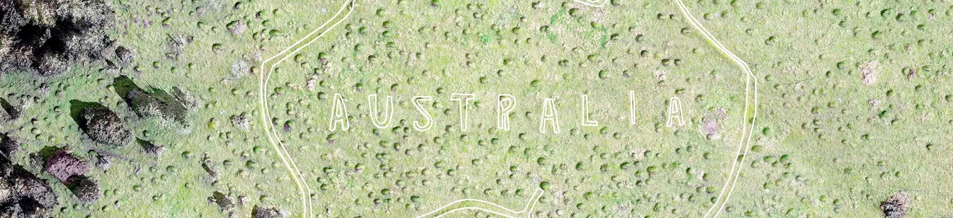
While convalescing at Hurdcott in southern Wiltshire during the First World War, volunteer members of the First Australian Imperial Force (1st AIF) carved the outline of Australia on the steep chalk scarp overlooking their camps. They wrote 'Australia' across the middle and there was even a flagpole.

Over time the chalk map became overgrown but a team of local volunteers – the Map of Australia Trust – have worked hard to reinstate the map for the centenary of the Armistice this November.
Supporting the Map of Australia Trust's volunteers
Historic England added the lost map to the Heritage at Risk Register in 2017. Over last winter we surveyed the site both on the ground and by using a drone, or Aerial Unmanned Vehicle (AUV).
Marking out the map
From the results we created a detailed digital 3D model to try to establish whether cuts from different dates were visible. The black hachure marks show subtle slopes or scarps and the edges of the flattish path along the chalk, before restoration. The small bumps are anthills.

Using this research we marked out the sides of the map so that local volunteers could accurately cut the line of the new chalk.
Researching the surrounding landscape
To help our understanding of the site we looked at aerial photographs and lidar data (an airborne laser scanning technique) and mapped archaeological features in the surrounding landscape.
Historic aerial photographs show traces – the camp roads and hut footprints – of the First World War camps in the valley below. The lidar data also reveals the distinctive chain link pattern of a nearby practice trench system, partly preserved in the trees at the foot of the hill.
We also mapped much earlier features like the ends of Prehistoric dykes that once crossed the ridge and patterns of trackways and fields on the steep scarp.
About the author

Name and role
Name
Sharon Soutar
Title and organisation
Graphics Officer
at Historic England
Details
Description
Sharon is a GIS and survey specialist in the Investigation and Analysis Graphics Team. Combining skillsets as a landscape archaeologist and graphic designer, Sharon has spent over 20 years working in various parts of Historic England.
Further information
We’ll have produced research report and the enhanced records are available through Heritage Gateway.
You can read more about other sites associated with First World War Commonwealth and Empire troops in our Heritage Calling blog
Find out more about the Map of Australia Trust
Watch BBC's regional ‘Inside Out’ magazine programme that aired on the 5 November 2018, featuring the reinstatement of the map.


