Revealing Lost Buildings at Bayham Old Abbey
New results shed light on the abbey’s hidden remains.
Geophysical survey at Bayham Old Abbey has provided key information about lost parts of the monastic complex. The results will be used to inform management of the site with the potential to present new interpretation in the future.
Bayham Old Abbey, situated in a quiet rural location on the Kent/Sussex border south east of Royal Tunbridge Wells, was founded shortly before 1211 by monks, originally from Prémontré in north-east France, belonging to a monastic order known as the Premonstratensians or White Canons.
Further building and later modifications continued through to the fifteenth century.
The abbey comprised a range of monastic buildings as well as the church – cloister, chapter house and infirmary, although the extent and layout of the infirmary have hitherto not been well established.
The abbey was suppressed by Cardinal Wolsey in 1525 and its buildings were largely destroyed. The surviving impressive ruins were partly repaired in the eighteenth century to provide a romantic view for Bayham Old Abbey House within a landscape designed by Humphry Repton. The estate later passed to the Camden family.
The need for better understanding
English Heritage requested a geophysical survey to clarify the development of the abbey and help the public to understand and enjoy the site.
Both the remains of the ruined abbey and a later Dower House - built to house a widow of the Camden estate - are in the care of the English Heritage Trust. The Trust requested a geophysical survey to clarify the development of the abbey and help the public to understand and enjoy the site. Specific questions for the geophysical survey were:
- where was the east wall of the original church, which was enlarged during the late thirteenth century to form the transepts and presbytery surviving at the site today?
- and where was the infirmary range, which is not represented by any of the standing remains?

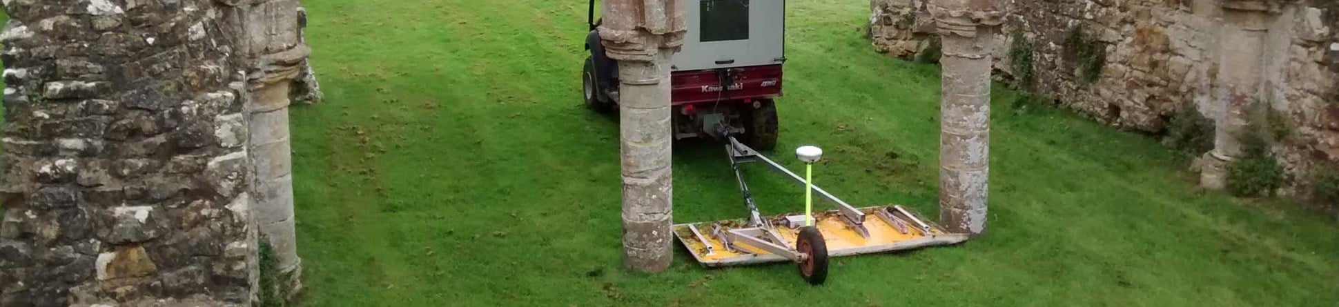
We decided that a closely spaced ground-penetrating radar (GPR) survey using a vehicle- towed system would be best to cover the majority of the guardianship site, although careful driving was required to manoeuvre the lightweight all-terrain vehicle through the abbey ruins.
Identifying the original east end of the church
The GPR data provided a detailed image of the buried remains to a depth of about three metres from the current ground surface. Foundations of the early thirteenth-century church still survive and produce strong GPR reflections, imaged as bright-white responses in the deeper data. The foundations of the east wall of the original church have been clearly detected from a depth of 0.65 metres as a substantial structure, approximately 1.5 metres wide, reaching far into the ground to support the superstructure of the building.
Combining this new information with evidence from the building fabric of the ruins has established for the first time the plan of the abbey church before it was enlarged.
It might be noted in addition that the level of detail provided in the GPR data is of such high resolution that in the near-surface results it is possible to discern both tree roots and individual mole runs immediately beneath the lawn, demonstrating that the technique is a powerful tool for identifying both archaeological and natural features.
Around the cloister and beyond
The plan of the original buildings around the cloister was not known with any precision. The wider area survey helped to confirm the location of the east wall of the chapter house and revealed a much larger suite of rooms at the south-east corner of the cloister, alongside the monks’ dormitory, known as a Dorter, which was located on the upper floor above an undercroft.
Perhaps more surprising was the extensive range of buildings associated with the site of the abbey’s infirmary to the east of the cloister, where no standing building remains currently survive above the ground surface. Wall footings in this area, appearing in the more shallow images of the data, demonstrate the former existence of structures around a large hospital building, together with some additional ancillary buildings to the north and a courtyard garden, between the infirmary and the Dorter to the west, similar in location to that found in other Premonstratensian abbeys.
The area to the east of the infirmary, where a group of mature trees had previously stood, was very uneven and the GPR antenna was unable to get good contact with the ground surface. However, a targeted survey using the slower earth-resistance technique provided equally clear results, especially after treatment of the data with a filter to enhance the appearance of buried walls. Despite the uneven ground the metal probes used to collect the data were able to make contact with the underlying soil and the results show more detail of the infirmary buildings extending into this area hidden under the rough ground.
Presenting the survey results
The results of the geophysical survey are available as a full research report and provide the potential to be incorporated into new interpretation of the site in the future. To help visualise the full GPR data set an animation of the data has been superimposed over a plan of the abbey remains showing how anomalies due to different structures occur at varying depths from the surface, thus informing the future management of the site.
About the authors

Neil Linford
Senior Geophysicist, Historic England
Neil Linford has experience across a wide range of applied geophysical techniques. Whilst his PhD research focused on the magnetic properties of archaeological sediments, he also has expertise in all aspects of the use of GPR. He is an editor of the journal Archaeological Prospection, has served as the chair of the NERC Geophysical Equipment Facility, and recently co-edited "Innovation in Near-Surface Geophysics" featuring contributions on many aspects of archaeological geophysics.

Andy Payne
Geophysicist, Historic England
Andy has specialised in the practice of archaeological geophysics since the early 1990s, working widely across England and occasionally in France, Spain and the Channel Islands. He has contributed to numerous reports and publications. His archaeological career has also included working on excavations in Orkney and on the site of the Roman amphitheatre in London.

Paul Lindford MSc
Geophysicist, Historic England
Paul has worked as an archaeological scientist for English Heritage and Historic England since the mid-1980s and is head of the latter’s Geophysics Team. He has particular interests in archaeomagnetic dating and in developing the team’s caesium magnetometer array. Paul is also Treasurer of the International Society for Archaeological Prospection and a member of the Geological Society’s Near Surface Geophysics Group committee.
Further information
Geophysical survey technical advice
English Heritage Visitor information
Linford, N and Payne, A 2017 Bayham Old Abbey, Frant, East Sussex: Report on Geophysical Surveys, October 2017, Historic England Research Report 72/2017


