Explore our research reports with this map which is an on-going project that allows access to the majority of research reports produced for place-based projects. It covers most types of non-invasive surveys, including scientific analysis, such as tree ring dating and archaeobotany.
Weston-Super-Mare: the View From Above
Historic aerial photographs of this Heritage Action Zone in Historic England’s Archive show Weston at war and peace.
A detailed review of the historic aerial photographs of Weston-super-Mare was undertaken as part of Historic England’s contribution to the town’s Heritage Action Zone (HAZ). Historic aerial photographs document changes to Weston-super-Mare over the last 100 years. They show the development of the seaside resort between the wars, some of the ways in which Weston was affected by the Second World War and the post-war rebuilding in the town.
Weston's seafront between the wars
The seafront was a popular subject for Aerofilms, the commercial firm that took many photographs of the town from 1920 onwards.
Many of the photographs illustrate the popularity of Weston as a holiday destination and show the range of buildings and structures built to cater for visitors. Weston Urban District Council took an active role in the provision of facilities and entertainments, which successfully attracted increasing numbers of holidaymakers to the town and August Bank Holiday visitor numbers rose from a pre-First World War peak of around 38,000 to 78,000 in 1937.
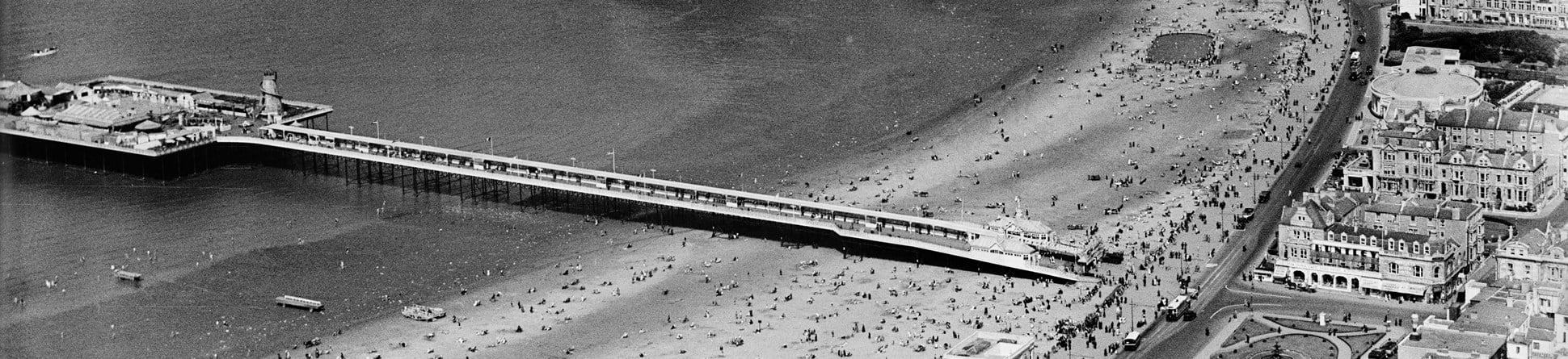
The town has two piers. The now derelict Birnbeck Pier was Weston’s first completed pier. It opened in 1867 and linked the mainland to Birnbeck Island, which serves as the pier head. The pier also welcomed visitors to the town arriving by steamer, a service that ran until 1979.

Weston’s Grand Pier remains a popular attraction and the historic aerial photographs document some of the changes made to this structure since it opened in 1904. Despite the addition of a low-water landing stage in 1906, which more than doubled the total length of the pier, problems with navigation and currents made it difficult for steamers to approach safely. A 1920 photograph shows this jetty, but it had gone by September 1928, demolished due to lack of use.
Fire destroyed the pier’s original pavilion in January 1930 and photographs taken in July of that year show the damaged remains. Work began on a new pavilion in the autumn of 1932, but in the intervening period temporary amusements were established on the pier and the site of the old pavilion was home to marquees, stalls and a helter-skelter.
Aerofilms photographs show a number of new developments built in the 1920s and 1930s. These included the creation of the Marine Lake (1927-29) with the building of a causeway between Knightstone Island and the mainland, and improvements to the adjacent Marine Drive.
A small bandstand was added around 1920, eventually demolished to make way for a slightly larger design (seen on aerial photographs taken in 1935). This too was short-lived, replaced by the large and partially enclosed Rozel bandstand in 1937.
The Winter Gardens pavilion with its large ballroom opened in 1927. The adjacent gardens included a lily pond, tennis courts and putting green. At the southern end of Weston’s beach, a large open air bathing pool with diving boards opened in 1937. Nearby and at about the same time, a new bandstand was built on Beach Lawn opposite Ellenborough Park. Also built on the seafront was the Beach Garage and Bus Station (now demolished) which opened in 1928.
Weston during the Second World War
Unlike seaside resorts nearer the continent, Weston’s seafront was free from barbed wire and anti-invasion defences during the Second World War.
In part this was also due to the unsuitability of its coast for landing enemy troops.
Instead, the threat to Weston was from air attack and many of the wartime structures seen in the 1940s aerial photographs are concerned with the war in the air. They include air-raid shelters, facilities for the fire brigade, anti-aircraft obstructions, barrage balloons and anti-aircraft batteries. The photographs also show the effects of air raids on the town.
Many of Weston’s air-raid shelters were built before the outbreak of the war and these included shelters in basements or small shelters in private gardens. The wartime RAF aerial photographs show 22 public surface shelters across the town, mainly on the seafront or by the public parks. Most of these were probably built before the outbreak of war, but a few, including two built on bombsites, were clearly constructed after the outbreak of hostilities. These long narrow structures were generally of brick with a flat concrete roof and each designed to shelter 50 people.
Britain’s fire brigades encountered a number of problems during the raids of 1940-41, including the failure of water supplies due to bomb-damaged water mains. In late 1941, to ensure that the fire brigade had reserves of water, Emergency Water Supply reservoirs (EWS) were constructed in towns and cities across the country. Fifteen EWS reservoirs have been identified in Weston, placed individually or in groups on open land: three large reservoirs were constructed on the lawns of Alexandra Parade, beside the Odeon cinema.
Weston’s first major air raid was in January 1941, but greater still were the raids over two successive nights in June 1942 when a total of 100 high explosive bombs and 10,000 incendiaries resulted in over 100 deaths. Most damaged occurred in the town centre.
The aerial photographs provide evidence of the effects of the air raids on Weston, showing bomb craters, bomb damage and cleared bomb sites.
The results of the raids were still apparent years after the end of the war and photographs taken in 1949 show bomb sites and the roofless ruins of bomb-damaged buildings.
Prefabs
Bomb damage contributed to the national housing shortage at the end of the war, a situation made worse by a shortage of builders and building materials. The building of prefabricated bungalows, more commonly known as prefabs, was a temporary measure to increase rapidly the number of homes. Over 156,000 prefabs in a variety of different designs were built across Britain immediately after the war, including at Weston-super-Mare.
Prefabs were intended to have a short lifespan and those built in Weston were demolished from 1960 onwards. Weston’s prefabs were all ‘Aluminium Bungalows’, a design entirely manufactured on a production line in five former aircraft factories, including the Oldmixon factory at Weston-super-Mare, built by the Bristol Aeroplane Company in 1940. Builders could assemble these in less than 24 hours and 54, 500 of this design were built across the country, more than any other type of prefab.
The Oldmixon factory produced other types of prefabricated aluminium buildings such as schools and these were sold at home and abroad. Aerial photographs taken in 1950 show a train about to leave the factory with a shipment of 26 prefabricated schools destined for Australia; this information was written on top of the wagons for a publicity photograph.
Historic air photographs
All the historic aerial photographs that we consulted for the project are held in the Historic England Archive, and the Aerofilms photographs can also be viewed online. They show what could be termed ‘lost landscapes’ and provide views of sites or structures that have since been demolished or significantly changed. In some cases, the photographs provide the only visual record of some of these sites, as is the case for many of the short-lived Second World War structures across the town.
The historic images provide a link with the town’s past, its war years, the seafront and to the many thousands of visitors who enjoyed their annual seaside holiday at Weston-super-Mare.
About the author

Edward Carpenter
Aerial Investigator at Historic England
Edward has worked for Historic England and its predecessors since 1998, and moved to the Aerial Investigation and Mapping team in 2002. He has worked on a number of multi-period aerial investigation projects across England and is currently analysing the historic aerial photographs of Longton Heritage Action Zone, Stoke-on-Trent. He has contributed to a number of Historic England research reports, including that on Weston-super-Mare.
Further information
Carpenter, E 2018 Weston-Super-Mare, North Somerset: Great Weston Heritage Action Zone, Aerial Investigation and Mapping Project, Historic England Research Report 50/2018
The Aerofilms Collection can be viewed online.


