Marshlands of Kent Reveal Historic Treasures
From a rare 17th-century pond built to trap ducks, to a decoy oil depot built to deceive German bombers during the Second World War, Historic England experts have been uncovering and protecting the extraordinary historic sites of the Hoo Peninsula in North Kent.
- New book explores thousands of years of Hoo Peninsula’s history
- Unusual 17th century duck decoy pond protected
- Extremely rare and well-preserved WWII oil storage depot built as a decoy by Churchill’s Petroleum Board now protected
- Two Boundary stones marking outermost limit of the City of London’s control of rights on the River Thames listed

The heritage of the Hoo Peninsula has until now been little known beyond the local area, despite being only 30 miles from the capital. Historic England experts have researched and mapped the landscape, archaeology and development of this area of north Kent. They say that many of the events and activities that have taken place here over the centuries have been part of much bigger stories with national, and sometimes international significance.
On the advice of Historic England, the Department for Culture, Media and Sport has granted protection to four sites – a Second World War bombing decoy site at Allhallows, a duck decoy pond at Halstow Marshes and two London boundary stones at Yantlet Creek and Upnor.
Sarah Newsome, Senior Investigator at Historic England said: “The duck decoy pond and oil decoy we investigated are fascinating examples, centuries apart, of the rich history of the Hoo Peninsula. These historic sites represent so many aspects of human activity, from putting food on the table to the preservation of life itself during the Second World War.
“Through this project, we have revealed that the Hoo has a complex history that goes beyond the familiar Dickensian idea of a low-lying land of misty marshes.”
Duck Decoy Pond, Halstow Marshes
The well-preserved and partly-waterfilled remains of a 17th century duck decoy pond on Halstow Marshes is the only surviving example of four such ponds that are known to have existed in Kent.
Ponds like these were introduced into England from the Netherlands and were often built by the gentry, gaining more popularity during the 18th and 19th centuries. Duck decoy ponds consisted of a central pond with a number of curving and gradually narrowing channels leading away from the main body of water. These channels, known as pipes, were enclosed with netting, and wildfowl that had settled on the pond were lured to the end of the pipes and caught.
Around 200 duck decoy ponds are known to have existed in England, mainly in the wetlands along the east coast from Yorkshire to Essex. The others in Kent include: Nagden Marshes near Oare, now only visible as a cropmark; Grovehurst decoy at Coldharbour Marshes, Sittingbourne now built over; and Kemsley, Kemsley Marshes, Sittingbourne, where no trace survives.
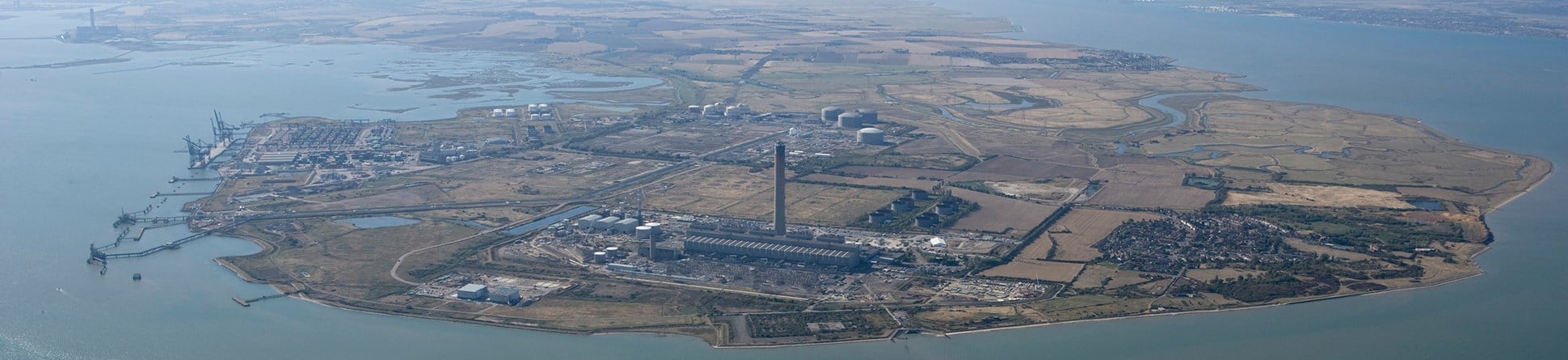
Oil Depot Bombing Decoy, Allhallows, Isle of Grain
The Second World War bombing decoy site at Allhallows was built by Winston Churchill's Petroleum Board in 1941 as part of a national programme of homeland defences to draw enemy attack away from real fuel storage facilities. During 1941-42, there were nearly 840 decoy sites in operation, ranging from dummy airfields and oil installations to decoy towns on fire.
The Allhallows decoy was situated around three kilometres to the north-west of a large complex of around 100 real oil storage tanks on the Isle of Grain. Remarkably, the entire decoy complex can still be seen in the landscape today, either as vegetation marks, structural remains or as archaeological features. They include five oil pools in the shape of rings and crescents and channels which held burning fuel. When set alight and viewed from above, the shapes created gave the impression of burning oil drums and storage tanks. The decoy was ignited electrically from a remote control building, the remains of which are also still visible.
London Boundary Stones at Yantlet Creek and Upnor
The London Stone Yantlet Creek which has just been listed dates to 1856 and was erected on the Isle of Grain. It has strong historic interest as the final obelisk to be erected by the City of London to mark the eastern boundary of the City’s jurisdiction over the River Thames. It also serves as a memorial to places along the River Thames and Medway where ceremonies were conducted by the Lord Mayor of London.
Because the River Thames was vital to the economic health of the City of London, the City exerted control over the Thames beyond the City’s own boundaries. From the 12th century until the mid-19th century, the City of London held jurisdiction over part of the River Thames and part of the River Medway and these boundaries were marked by both natural features and boundary stones. The City lost its control of rights on the river to the Crown in 1857 under the Thames Conservancy Act.
In order to remind people to observe the boundaries, the Lord Mayor of London and other officials made seven-yearly visits along the river. These trips would last about three days and included ceremonies at the stones to assert the City’s rights. The crowds who came along to watch the proceedings were rewarded with wine, beer and coins.
An obelisk erected in 1836 named New London Stone at Upnor has been listed and a nearby smaller 18th century boundary marker, London Stone at Upnor has been re-listed and its description on the National Heritage List for England expanded. They were erected to mark the southern boundary of the City of London’s jurisdiction over the River Medway.
New Book on the Hoo Peninsula Landscape
Historic England's new book on the whole history of the Hoo Peninsula is published today. 'The Hoo Peninsula Landscape' by Sarah Newsome, Edward Carpenter and Peter Kendall is part of Historic England's Informed Conservation series which highlights the special character of some of England's most important historic areas and the development pressures they are facing today.


