Reasons for Designation
Moots were open-air meeting places set aside for use by courts and other
bodies who were responsible for the administration and organisation of the
countryside in Anglo-Saxon and medieval England. They were located at
convenient, conspicuous or well-known sites, often centrally placed within the
area under jurisdiction, usually a hundred, wapentake, or shire. The meeting
place could take several forms: a natural feature such as a hilltop, tree or
rock; existing man-made features such as prehistoric standing stones, barrows
or hillforts; or a purpose-built monument such as a mound. Moots appear to
have been first established during the early medieval period between the
seventh and ninth centuries AD. Examples are recorded in the Domesday Book and
other broadly contemporary documents. Initially, moots were situated in open
countryside but, over time, they were relocated in villages or towns. The
construction and use of rural moots declined after the 13th century. The
normal form of purpose-built moot was the moot mound. These take the form of
large, squat, turf-covered mounds with a flat or concave top, usually
surrounded by a ditch. Occasionally, prehistoric barrows were remodelled to
provide suitable sites. It is estimated that there were between 250 and 1000
moots in medieval England, although only a limited number of these were man-
made mounds and only a proportion of these survive today. Moots are generally
a poorly understood class of monument with considerable potential to provide
information on the organisation and administration of land units in the Middle
Ages. They are a comparatively rare and long-lived type of monument and the
earliest examples will be amongst a very small range of sites predating the
Norman Conquest which survive as monumental earthworks and readily appreciable
landscape features. On this basis, all well preserved or historically well
documented moot mounds are identified as nationally important.
Details
Alsthorpe deserted medieval village stands on relatively high ground to the
east of the B668, mid-way between the villages of Burley and Cottesmore. The
monument consists of a substantial mound, identified as a moot or meeting
place, and the earthwork remains of the medieval village.
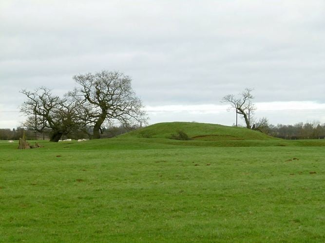
Alstoe moot is a large irregularly-shaped mound, about 35m in diameter and 5m
high. Surrounding the mound is a heavily silted ditch 8m wide and 1.5m deep.
On the southern and western sides of the mound are two very pronounced
straight ditches 8m wide and 1.5m deep which appear to mark the edges of
adjacent enclosures. Adjacent to the mound are the deserted medieval village
earthworks which include a series of house platforms and garden plots located
on either side of a north-south running holloway. The outlines of rectangular
buildings are still discernible on some of the platforms.
Excavations of the moot and the straight ditches have shown them to be
contemporary and of Saxon date. The site is also mentioned in the Domesday
Book, and there is a documentary reference to a large `green' ditch next to
`Altiechestouwe' in 1207. The village may have Saxon origins but was
certainly occupied from the Norman period until its desertion in the 15th or
16th century.
Legacy
The contents of this record have been generated from a legacy data system.
Legacy System number:
17009
Legacy System:
RSM
Sources
Books and journals
Legal
This monument is scheduled under the Ancient Monuments and Archaeological Areas Act 1979 as amended as it appears to the Secretary of State to be of national importance. This entry is a copy, the original is held by the Department for Culture, Media and Sport.
End of official list entry