The Roman Landscape Characterisation and Prediction Project
 Paul Chadwick FSA, MCIfA
Harnessing the potential of existing knowledge to develop predictive models of Roman settlement.
Context for the project
The quantitative and qualitative explosion in archaeological data since the 1990s provides an unparalleled opportunity to improve our understanding of landscapes and to venture into the unexplored field of archaeological site prediction. Interestingly, with the publication of a revised National Planning Policy Framework (NPPF) in 2021 requiring local planning authorities use their Historic Environment Record to ‘predict the likelihood that currently unidentified heritage assets, particularly sites of historic and archaeological interest, will be discovered in the future’ (paragraph 192), this project gained additional relevance. Of course, the required predictive process can and is being undertaken routinely by local government archaeological officers and other heritage professionals, albeit often on an intuitive basis.
However, as the volume of data continues to balloon, the ability of the human brain to reliably process and extrapolate becomes increasingly questionable – machine-based predictive models can provide evidence-based models to assist the decision-making process.
The Roman Landscape Characterisation and Prediction (RoLCAP) project, has developed several models addressing Roman rural settlement in areas across central and southern England.
Now in its fifth year, it has two main themes: the characterisation of the Roman rural landscape at a local scale, and the prediction of where yet-to-be-discovered Roman farms and villas might be found.
Together they provide a methodological approach to enable informed, landscape-scale responses to land use change. Given sufficient computing power and adequate relevant data, ‘characterisation’ (the identification of key aspects of farm location and morphology) can be a relatively straightforward, if somewhat time-consuming, process. This essential first step enables a better understanding of the landscape, and, at least until machine learning is let loose at scale on archaeological literature, forms an essential first step to developing predictive models. In short, we need to fully understand the known resource in order to build useful predictive models.
Untapped potential
The last decade or so has seen increasing frustration amongst academics and heritage professionals that the dividend of more than thirty years of archaeological investigation has generated plenty of new ‘blobs on maps’, but has generally failed to move our understanding of Roman agriculture at a regional landscape scale forward; vast quantities of evidence were (and still are) languishing largely untapped.
This frustration saw a team from Reading University and Cotswold Archaeology develop the ‘Rural Settlement of Roman Britain Project’, analysing published and ‘grey lit’ excavation reports to inform a wide-ranging reassessment of the countryside of Roman Britain (Smith et al 2016).
In parallel, at the University of Oxford, the ‘English Landscapes and Identities (EngLaId) project team drew on almost every English Historic Environment Record, Historic England and Portable Antiquity Scheme data to investigate landscape change from 1500 BC to AD 1086, taking account of the influence of ‘events’ (individual episodes of archaeological work) and the resulting ‘characterful’ datasets on which archaeological interpretations are based (Gosden et al 2021).
Exploring Roman farming
We still know relatively little about the detailed nature of agriculture carried out across Roman Britain.
Haven’t the Roman Rural Settlement Project and English Landscapes and Identities (EngLaId) projects said it all? Well, not quite - we still know relatively little about the detailed nature of agriculture carried out across Roman Britain, and about whether and how this varied on a regional basis: were these farms engaged in an almost fortuitous mix of arable and stock farming, which, in a good year, generated sufficient surplus to eat well and pay taxes, and in a bad year resulted in hunger and tax defaults.
Or had generations of farming experience developed specialised strategies, with stock and crops balanced to soil type, resulting in a regular surplus?
Is the often-presented idyllic view of the Roman countryside even vaguely accurate?
The Roman Landscape Characterisation and Prediction project aims to better understand the influence of cultural aspects, topographic factors and ‘events’ on our interpretations, and attempts the prediction, at a variety of scales, of farm locations.

Roman Landscape Characterisation and Prediction Project: nuts and bolts
Initially, three Study Areas each 14 kilometres by 14 kilometres (196 square kilometres), centred on urban growth areas in Berkshire (Wokingham/Bracknell), Oxfordshire (Didcot) and Wiltshire (Swindon) and known to have been subject to numerous ‘events’ were selected. These were subsequently augmented, as new research questions arose, by further study areas including those linking the Didcot and Swindon Study Areas and complementing data from the ‘Atlas of Hampshire’s Archaeology’. For more information see an explanatory GIS ‘story map’.
Probably the most significant statistic generated by the project has been the calculation of a series of farm densities per square kilometre by soil type and geology, with a parallel set of density figures for field systems. These figures, once contextualised through a consideration of ‘event history’ within each study area, underpin the characterisation process and subsequent predictive modelling.
Towards a better understanding of the Roman landscape
Evidence from Roman Landscape Characterisation and Prediction project’s 1,500 square kilometres of Roman rural landscape strongly suggests that the rejection of ‘geographic determinism’ by geographers and archaeologists in the mid and late 20th century may have ‘thrown the baby out with the bathwater’.
Thus, whereas in the 1920s and 1930s, OGS Crawford and other landscape-focussed archaeologists took an association between settlement pattern, farming, vegetation, soil and topography for granted (see for instance the Ordnance Survey Map of Roman Britain of 1928 (2nd edition) prepared under Crawford’s direction; subsequent generations have largely ignored these interrelationships and somewhat of a theoretical vacuum has pervaded Roman studies.
Analysis by the Roman Landscape Characterisation and Prediction project suggests a rebalance is needed; results suggest that geology, soil type and other topographic factors are fundamental to the location of farms and the character of farming across the landscape.
Within the framework provided by Natural England’s National Character Areas, the Roman Landscape Characterisation and Prediction project has built a picture of different settlement patterns and farming regimes.
For instance, Character Zone 1b (Thames Gravel Terraces/Sutton 1 soils) is evidenced by the highest farm density per square kilometre by geology and soil type, a fully settled and farmed landscape with the late Iron Age, and continuity of late prehistoric settlement and field systems until reorganised in the early 2nd century AD.
The mid/late Roman landscape comprises an intensively farmed landscape centred on farmsteads, with surrounding field systems, trackways and unenclosed areas of pasture, village-scale settlement and villas. All settlement types have easy access to water supply and access for stock, via trackways, to unenclosed pasture and nearby floodplain hay meadows. Archaeobotanical material evidences a wide range of cereal crops, with some centralisation of crop processing implied by millstones.
Farms in this Zone average around 100 hectares and palaeoenvironmental evidence suggests woodland had been completely cleared, with lime and other individual trees probably confined to hedgerows. In contrast, Zone 6 (London Clay) is characterised by a largely empty Iron Age landscape, a low density of artefact-poor (Roman) farmsteads, limited field systems, an absence of villages and villas, and an average farm unit size approaching 1500 hectares – large scale cattle farming within a heavily wooded environment is suggested.
Crystal ball gazing or sound science?
Several innovative predictive models have been developed and tested. Initially, farm densities on nine soil types around Didcot were used to predict the potential number of farms on similar soil types in the Swindon Study Area. Historic Environment Record data for the Swindon area was then used to test the predicted farm values. Interestingly, although farm density values differed subtly between areas, the hierarchy of preferred and less-favoured soils (high farm values and low farm values) was virtually identical, with differences explained (but difficult to quantify) by differing ‘event histories’ and proximity to the Roman road network.
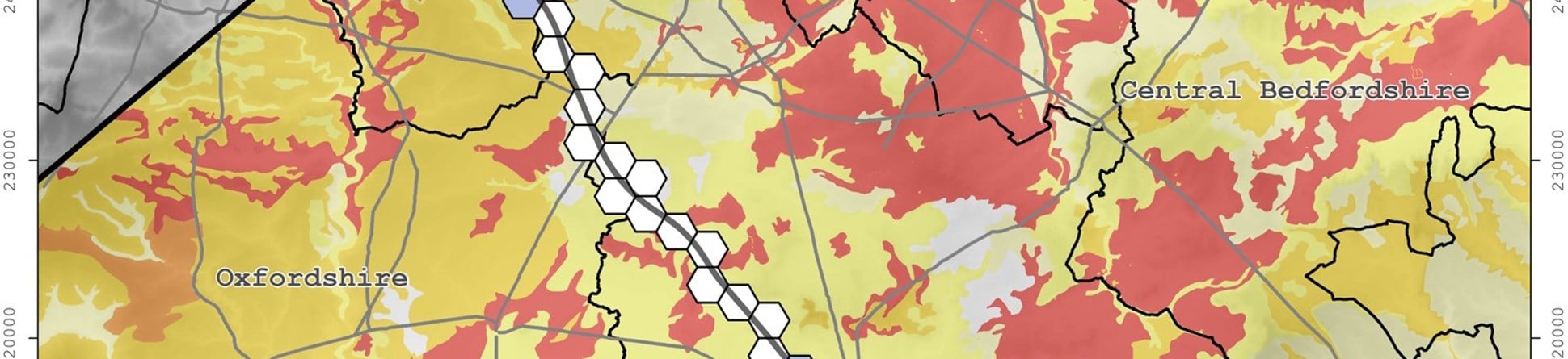
At a landscape scale, farm densities by (simplified) soil type from around Didcot were applied to similar soil types in the Oxford-Cambridge Arc (an area for which the government is developing a framework for sustainable economic growth). The model generated is rudimentary, and is undoubtedly flawed, being based largely on data from outside the modelled area. However, this obvious short-coming has subsequently been partially rectified by the inclusion of data from a small study area within the Arc (in Central Bedfordshire) and, following the provision of recent archaeological data from the HS2 route across the Arc, further testing and refinement of the model is proposed. Nevertheless, the methodology enables the identification of areas of high, medium and low potential for Roman rural (farm) settlement across numerous local authority areas.
Where next?
Further work is needed to test the evidence base and characterisation process in other National Character Areas. Meanwhile, an increasing understanding of the pitfalls of predictive modelling gained from the current phase of validation, and the continued flow of new data from excavations will add further refinement, improvement and reliability to this predictive modelling tool.
Conclusions
In addition to providing a much-improved understanding of Roman agriculture across different landscapes in central and southern England, the Roman Landscape Characterisation and Prediction project provides a novel methodological approach to predictive modelling which could assist strategic decision makers assess the archaeological implications of large-scale development proposals and other land use change.
The assessment of large-scale landscape change, particularly those extending across several local authority boundaries, is currently hindered by multiple data sources and the uneven distribution of archaeological events resulting often in misleading distribution maps and a likelihood of unexpected discoveries or unrecorded damage to archaeological assets. Needless to say, predictive modelling is unlikely to ever prove 100% reliable, however, it can provide comprehensive evidence-based opportunities at a strategic and local level to identify areas of potential where further survey and investigation might be targeted.

Further information
Gosden, C, Cooper, A, Creswell, M, Donnelly, V, Franconi, T, Glyde, R, Green, C, Kamash, Z, Mallett, S, Morley, L, Stansbie, D, and Ten Harkel, L 2021: English Landscapes & Identities Investigating Landscape Change from 1500BC to 1086 AD. Oxford: Oxford University Press
Smith, A, Allen, M, Brindle, T and Fulford, M 2016 ‘The Rural Settlement of Roman Britain: new visions of the countryside of Roman Britain’. Volume 1. Britannia Monograph 29. London: Society for the Promotion of Roman Studies
Download in PDF Format
You can download this article along with the others in this issue as a PDF magazine.


